
Google Maps Ups Its Game with Mixed-Mode Navigation
 meiwphotographer / Shutterstock
Toggle Dark Mode
Although we really think you should give Apple Maps a try as it’s improved in leaps and bounds over the past few iOS releases, there are a lot of folks who still swear by Google Maps, and with Google also still iterating and adding new features regularly, it’s becoming an interesting race between the two well-known mapping apps.
In fact, Google Maps is becoming even more at home on Apple devices, with Apple letting it plug into CarPlay with iOS 12 last year, and iOS 13 promising to bring expanded Siri support. Meanwhile, Google has recently added augmented reality support for navigation, while Apple will be adding its own version of street view starting in iOS 13.
Now Google has raised the stakes again with the addition of “mixed-mode” navigation — a feature that lets you combine multiple forms of travel when getting navigation directions.
Travelling the Last Mile
According to Google’s blog, the new feature will allow you to plot a navigation route between two points that and receive the best combination of transportation modes to get you there with minimal walking or in the shortest time.
For example, a trip on public transit to a friend’s house can now offer the ability to hail an Uber or Lyft to complete the trip from the nearest bus stop or subway station, rather than simply suggesting you walk to the destination. Or bicycling directions might be offered to get you to the nearest bus stop to help you catch the bus on time.
It’s actually not a new idea, to be fair. One of our favourite transit apps — Transit — added this same capability several months ago, with even more tie-ins for things like bike-sharing services. However, it’s definitely a bigger step to see it come to a mainstream app like Google Maps, and will hopefully spur Apple to soon do something similar with Apple Maps.
How It Works
As Google explains, you can ask for directions in the normal manner — simply enter your destination in the search box and tap on “Directions” and then switch over to the “Transit” tab. In addition to the bus, train, and streetcar routes that are normally shown here, the list will now begin to include ridesharing and cycling options mixed in.
For ridesharing trips, information will be provided such as the cost of the ride, how long you’ll have to wait for it, and if there’s traffic on your route. Bus and train departure times will also be shown to help ensure that you make the necessary connections if you’re taking a rideshare to a transit stop or station. You’ll also be able to choose your preferred rideshare provider, such as Uber or Lyft, as well as customizing ride options.
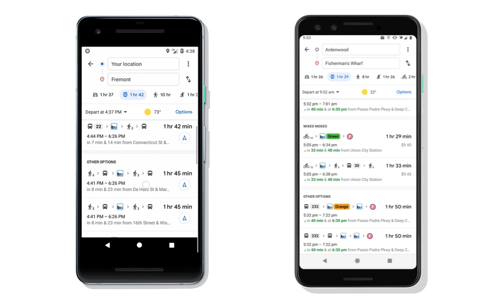
Cycling directions will include routes specific for that purpose, including optimal cycling pathways, and this will also be factored into your total travel time and ETA. One thing that the new feature doesn’t yet appear to support is offering different modes of getting between two public transit systems — for now it’s only for getting to transit stops and stations at the beginning or end of a trip.
Google says that the new feature is being gradually rolled out “in the coming weeks” to Google Maps for iOS (and Android) in 30 countries around the globe, so if you’re not seeing it yet, it should be available soon.