
How Apple’s Latest ‘LiDAR’ Patent Could Improve Maps and Pave the Way for the Apple Car

Toggle Dark Mode
Apple has been aggressively trying to expand upon its geospatial data rendering capabilities lately, with one of the company’s latest research endeavors focusing exclusively on various sensors and systems related to the field of 3D mapping.
Fortunately for Apple, it appears the company was recently granted a patent that exclusively pertains to its own in-house LiDAR mapping device — which could effectively enable the Silicon Valley tech-giant to vastly improve its own ability to capture cityscapes and landscapes and monuments, alike, in immersive, three-dimensional depth and clarity.
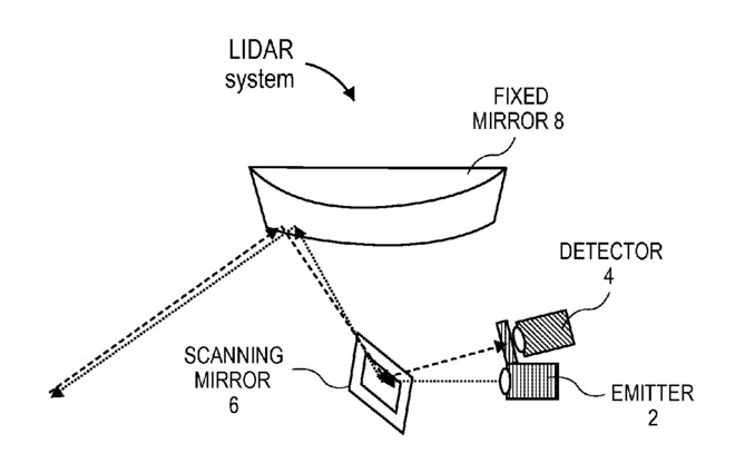
The patent — which was, strangely enough, granted for a quote unquote, ”3D depth point cloud from timing flight of 2D scanned light beam pulses,” essentially details the hardware and functional specifications of a new type of LiDAR sensor. And by the way, just in case you were scratching your head there, the term “LiDAR” is essentially a mash-up term, combining pragmatic elements of the words “light” and “radar.”
In any case, Apple’s patent appears to exclusively detail a design that includes several specific elements — including a fixed mirror, a scanning mirror, a photodetector, and a laser emitter, rendering it perhaps one of the most comprehensive LiDAR protocols to see the light of day.
Apple ultimately decided upon pursuing its own LiDAR technology because, as it states in the patent filing, “current sensing techniques could suffer from excessive power consumption, limited horizontal-vertical resolution, limited depth resolution or accuracy, limited frame rate, and long product development cycles.” In theory (and practice), the company’s home-brewed LiDAR system could mitigate at least some, if not all, of those aforementioned concerns.
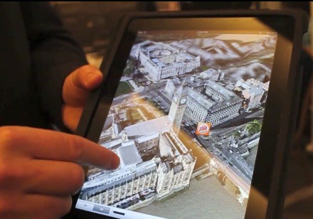
One of Apple’s primary focuses lately has been to improve the accuracy of three-dimensional spatial renderings — especially as the company seeks to enhance its own, home-brewed mapping software. In addition to commercially available products, however, this type of super-accurate, 3D mapping data is integral to the development of self-driving vehicles. And, as you may be well aware by now, Apple has been rumored to be working on an autonomous, self-driving, self-branded automobile — for which the LiDAR protocol could also be of great benefit in the long run.
Of course, even if Apple ultimately does decide to adopt its own in-house LiDAR technology, such a move wouldn’t be the first time a major player up in Silicon Valley did the same.
Towards the tail end of 2015, for instance, Google revealed that it had developed its own solid state LiDAR system that could be manufactured for less than $1,000 each — this, compared to some alternative, commercially available options that can run upwards of $75,000 a pop, even in large quantities.
Either way, though, this move could drastically enhance both the quality and accuracy of Apple Maps down the road, so it’ll be interesting to see what ultimately comes from this new patent.
Scott T. Smith, Matthew E. Last, and Edward A. Valko have been credited with the invention of Apple’s LiDAR patent, which was filed under U.S. Patent No. 9,285,477.
Learn More: More iPhone 7 Photos Leak – Now Featuring Dual Cameras and Smart Connector Capability
[The information provided in this article has NOT been confirmed by Apple and may be speculation. Provided details may not be factual. Take all rumors, tech or otherwise, with a grain of salt.]