
Apple Maps Is Getting Automatic Hazard Alerts in Exciting New Update
 HAAS Alert
Toggle Dark Mode
Apple Maps has come a very long way since its fledgling days when even the company’s top execs had to admit it was an embarrassment, and now it’s partnered with a new road monitoring service to make your travels even safer.
HAAS Alert, a company with a mission to “make vehicles and roads safer and smarter,” has announced a new partnership with Apple to integrate its Safety Cloud digital alerting platform into Apple Maps.

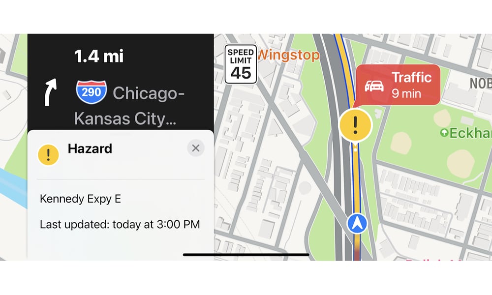
While Safety Cloud isn’t a new service — it’s been available to Waze users since it first launched in 2017 — its addition to Apple Maps promises to bring it to a whole new audience, allowing motorists to get real-time information and alerts when approaching emergency vehicles, incident responders, work zones, and other road hazards.
As HAAS Alert notes, Apple Maps is “one of the most widely used mapping, navigation, and traffic solutions in the world,” which is understandable since it’s pre-installed on every iPhone. While there may have been a reason for users to seek out Google Maps in the early days, Apple Maps had pulled ahead of Google Maps by late 2015, and with every new iOS update, there have been fewer reasons for iPhone users to choose anything else.
While rivals like Waze have traditionally had the edge when it comes to reporting things like road hazards, Apple has been quickly catching up. iOS 14.5 added support for user-reported accidents, speed checks, and general hazards, and it works remarkably well. You can report incidents via Siri, so you never have to take your hands off the wheel. Plus, if you’re approaching a hazard reported by somebody else, Apple Maps will prompt you to confirm if it’s still there or whether it’s been cleared.
Until now, however, that’s been mostly limited to user-reported hazards. That kind of crowdsourcing is great when people cooperate, but it’s easy for things to slip through the cracks if drivers can’t be bothered identifying them. This is where HAAS Alert’s Safety Cloud comes in.
With over 1,200 organizations participating, including public safety agencies, roadside assistance fleets, tow truck operators, and road workers, there’s a much better chance that reports of accidents and hazards will find their way onto your iPhone or CarPlay screen when using Apple Maps.
According to HAAS Alert, many emergency vehicles, telematics systems, and traffic management platforms are already tied into Safety Cloud to provide automatic alerts. In this case, there’s no button for an emergency responder to push; Safety Cloud gets notified and updated automatically.
As the company’s announcement notes, studies from Purdue University and the University of Minnesota have found that roadway hazard alerts can reduce the risk of crashes by up to 90 percent near roadside incidents. By being aware of what’s coming, drivers can safely slow down and proceed with caution. It’s also estimated to reduce hard-braking by up to 80 percent, which your vehicle will thank you for.
With the addition of Apple Maps as a Safety Cloud digital alerting partner, drivers using an iPhone as a travel companion will now be safer and better aware of upcoming roadway conditions. We applaud Apple for prioritizing driver safety and taking steps towards achieving the Vision Zero goal of eliminating all traffic fatalities and severe injuries.Jeremy Agulnek, HAAS Alert’s SVP of Connected Vehicle
Safety Cloud is available globally, but it’s not clear if the Apple Maps partnership extends outside the U.S. quite yet, or even if alerts from Safety Cloud will be shown differently from user-reported hazard alerts. However, at the end of the day, how a hazard was reported shouldn’t matter nearly as much as getting the hazard alert in the first place.